


Col Vinayak Bhat for India Today. Read the original article here.
 [REPRESENTATIVE IMAGE] File photo of Three Gorges Dam in China’s Hubei, world’s biggest hydropower project (Photo Credits: AP)
Over a period of 10 years, China has managed to construct three dams on the Brahmaputra river in parts of Tibet close to the Indian border. It plans to construct at least eight more such dams.
China’s rapid pace of dam constructions that includes at least eight new ones on the Brahmaputra River in Tibet has sparked concerns about the Chinese attempting to tame India’s water supply. The proposed dams on the Yarlung Tsangpo river in Tibet are close to the Indian border in Arunachal Pradesh.
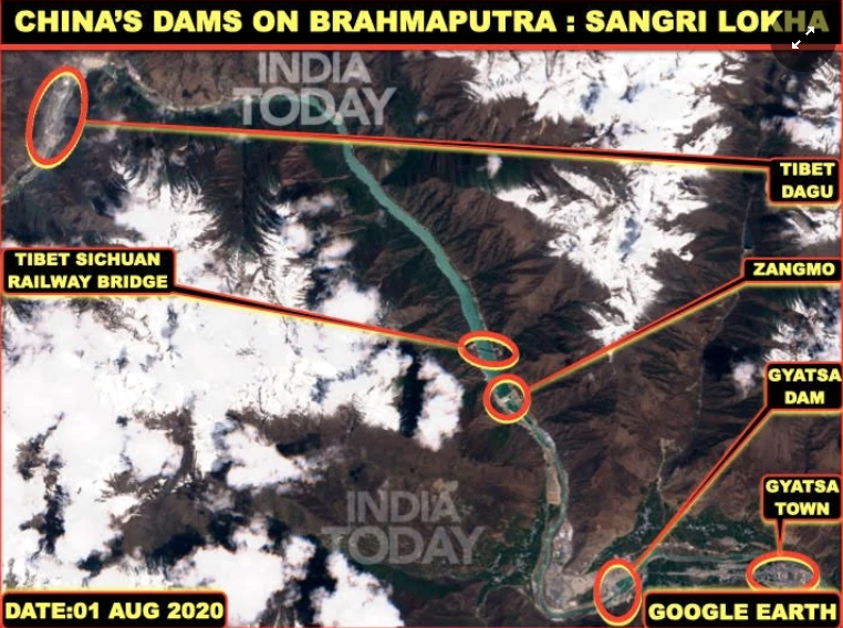
In this region, the Chinese have managed to construct three dams within a distance of 24 km on the Brahmaputra River over a period of 10 years. This construction of dams at an unprecedented pace and scale has taken place in Tibet’s Sangri Lokha. Construction of a similar ‘triplet dam’ has been observed on the Nyang river near the town of Nyingchi in Tibet’s Nyingchi county.
Lokha, also known as Shanan lies in the northeast of Bhutan and south of Lhasa while Nyingchi is further east, both bordering Arunachal Pradesh.
 Satellite image of Sangri Lokha (Photo Credits: India Today)
In order to find out the aim of these massive construction projects, India Today OSINT team investigated them using Google Earth images.
The ability to control India’s water supply in the hands of the Chinese has always been a legitimate concern. China can use this to cause flash flooding or to divert water that could dry up rivers across India.
Zangmo Dam
A comparative analysis of satellite images of the Zangmo dam shows how its width has increased fourfold from 100 m in 2012 when the construction began to 400 m as seen on August 4, 2020, while the water levels have risen almost 150 m.
Thus, the reservoir which spans across almost 10 km can hold more than 600 mn cubic meters of water, an indication that a massive amount of water is under Chinese control in Tibet.
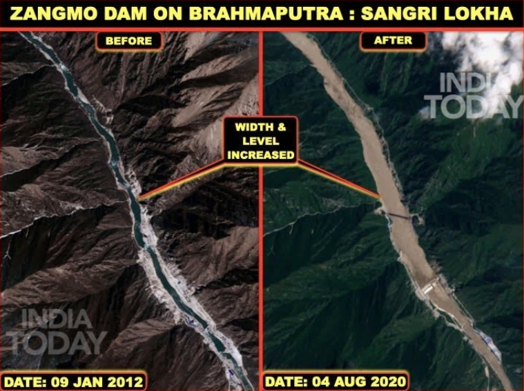 Satellite image of Zangmo dam on Brahmaputra in Sangri Lokha (Photo Credits: India Today)
However, government sources say these dam constructions are being monitored closely. “It is something that has always been discussed between the two governments closely,” a government official tracking developments in this regard asserted. While claiming that the threat of China using these dams to cause flash flooding or block water to Indian territory is not visible, sources said, “For flash flooding, water has to be accumulated but there has not been anything abnormal that has been noticed.”
Amid the India-China military standoff in eastern Ladakh, Chinese activities including dam constructions along the Indian border are under the scanner once again.
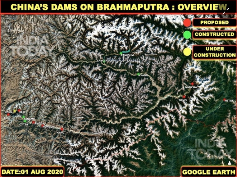
New dams proposed on the Brahmaputra
China has proposed to build at least eight more dams on the Brahmaputra River in Tibet. These dams are to be built within the next 10 years at Bayu, Jiexi, Langta, Dakpa, Nang, Demo, Namcha and Metok towns that do not have more than a hundred households each. This has sparked speculation that the aim of these dams is only to build reservoirs and export electric energy from Tibet to mainland China.
 Satellite image of new dams proposed by China in Tibet (Photo Credits: India Today)
Need for shared data on dam construction, water flow
Satellite images very clearly indicate that China is not building a large number of dams on the Brahmaputra River for the benefit of the people of Tibet. The area is scantly populated and electricity demands in the region could be met with a single hydroelectricity project like the Zangmo dam.
The Chinese could also aim to use these dam reservoirs such as the Dagu dam to divert Brahmaputra’s water to dry areas in Xinjiang or Central China. Evidence for such diversions is yet to come to light. However, reports have cited locals talking about it in recent years.
The third and perhaps the most worrying explanation for China storing water at eleven dams on the Brahmaputra River could be to control the water flowing into India.
Experts feel China’s dam construction is a key concern and the Chinese dispensation must be more transparent over the issue. Director of the Kubernein Initiative, Ambika Vishwanath tracks water diplomacy and security across the globe. She feels it is not just the quantity but also the quality of water that should be a matter of concern in the long run.
“There needs to be a closer study on not just the quantity of water flow but also the quality which can be extremely detrimental in the long run. It can have an impact on people’s lives in downstream regions. There are very little information and an understanding of the region. The entire Himalayas is a black hole of data,” Ambika says. She further added, “Scientists, researchers need more access to the areas and require more data to understand short and long term impact to aid in better policymaking.”
Ambika also says that one way of ensuring more transparency is joint initiatives, such as data sharing or construction of dams within joint management of river basins, but that does not seem likely anytime soon. “If there are joint constructions, responsibilities are also shared to safeguard installations on either side,” she points out.
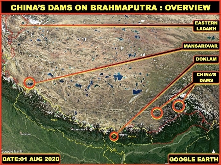 Satellite image of Chinese dams on the Brahmaputra (Photo Credits: India Today)
Use of water supply as a weapon against India?
Blocking India’s water supply even for a few days can lead to rivers drying up across the country.
On the other hand, many feel low lying areas in India will be completely inundated if China suddenly releases all this stored up water, as seen in the case of the Three Gorges dam in Hubei province. A purposeful release of water from all the dams on the Brahmaputra can wreak havoc in India, many feel.
As per Indo-Sino bilateral agreements, China is expected to share data with India during the monsoon in order for the latter to keep track of water levels and prepare for floods.
After Pasighat in Arunachal Pradesh, the Brahmaputra River expands to almost 10 km in width. Its width varies from 8 to 10 km in Assam. Bridges in these states are surprisingly smaller than the width of the river. During monsoon every year, the bridges get flooded with their abutments almost always underwater.
Careful monitoring of these dams will provide a 15-day early warning since this is the time it takes for river water to travel from Tibet’s Lokha county to Pasighat in Arunachal Pradesh.
Zangmo, Gyatsa, and Dagu
There are three dams on the main Brahmaputra River built in unusually close proximity to each other. These dams are located within a very short distance of 24 km. With only the single village of Gyatsa and its population of barely 150 households, having three dams is unprecedented.
While the Zangmo dam has been commissioned, the Gyatsa dam is complete and awaiting commissioning. The third and largest of the trio, the Dagu dam has been under construction since 2017.
 Satellite image of Dagu dam on Brahmaputra (Photo Credits: India Today)
Dagu surprisingly has two inlets and two outlets for water to pass through the mountain despite it being a run of the river hydroelectricity dam. Such dams have electricity generators underground, in an area below the dam, and do not require additional tunnels for water flow.
This has led to doubts supported by rumors that Brahmaputra’s water may be diverted to the dry Xinjiang deserts through underground tunnels using the Dagu dam. Once all three are complete, the triplet dams will be able to collect almost a billion cubic meters of water in their reservoirs.
Pagsum, Langsai and Nyang
The three dams in Nyingchi county are being constructed on a tributary called Nyang that feeds Brahmaputra River. The dams at Pagsum, Langsai, and Nyang are much smaller in size but hold enough water to add to the Brahmaputra River flow.
Land barrier dam
Around October and November of 2018, rumor had it that China had clamped down on the Brahmaputra river and water flow had almost come to a halt. Reports of water being unusually muddy at the time had also come to light.
Satellite images revealed much later that a large landslide from the southeastern face of Sodong Ri Mountain had blocked the Brahmaputra almost completely.
International obligations dictate that China must seek permission from downstream countries before constructing any dam upstream on the Brahmaputra river. Despite its bilateral agreements with India, China still does not share any data in this regard.
Although New Delhi is paying a hefty sum of Rs 80 lakhs to Beijing for this data each year, the response India gets from the Chinese every time is the same- water in the Brahmaputra river washed the measuring instruments away.


